 Legend has Britain's first church founded at Glastonbury by a band of Apostles who fled north on the old tin-trade route from Palestine. (For DaVinci Code fans, the legend does in some versions include Mary in this group of refugees, though this may not be Mary Magdalene, but the Virgin Mary.) The group landed somewhere on the southwest coast, and selected Glastonbury as the site of their church, being given sanctuary and land by the Celtic chieftain there. This is why Glastonbury is still called 'the cradle of Christianity of Britain' by English churchgoers (See item on the annual Glastonbury Pilgrimages, below).
This long-distance tin trade is historically documented, but the location of the ports where the traders came to bargain for the tin-ore then found in abundance in SW Britain is still a matter of speculation. Various towns around the Southwest have legends or rhymes, kept alive by Cornish tin miners that may relate to this. They concern Joseph of Arimatheia, Jesus's supposed uncle (who claimed his body from Pilate), landing there as a tin-trader, and even bringing Jesus himself here on an earlier visit, as a boy. In the later Grail legends, it was Joseph Of Arimatheia who brought both the Apostles and the Grail, post-Crucifixion, to Britain.
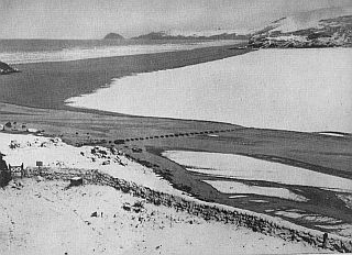
The tin-trade route, according to Roman accounts, terminated in a series of offshore islands, where the locals brought the tin ore for trade and trans-shipment to Gaul. Offshore islands where traders could draw their ships up on the beach would certainly offer a suitable venue here, on the rocky and stormy southwest coast. However the coast has changed since the Celtic period. Glastonbury, a tidal inlet and island in the Celtic era, is now land-locked, while another popular choice for the sought-after tin-trade port, the tidal islet of St Michael's Mt in Penzance Bay, was then surrounded by forest. Yet other settlements still seem to have vanished beneath the waves due to natural processes of erosion and flood that are still ongoing. The 'Scilly Isle' a Roman writer mentions is now the Isles Of Scilly, with fragments of road and wall still visible in between them at very low tides. Some have argued that the Cornish legend of the sunken land of Lyonesse (which Tennyson compared to Avalon in his Arthurian poems) is a folk-memory of the sinking of Scilly or another Celtic-era island-port. Another such legendary tin-trade entrepot, farther along the North Cornish coast, was called 'Langarrow.' The archival photo above shows its site under snow in 1947. According to legend, it was destroyed by the wrath of the Lord, i.e. a sandstorm. A chapel was later found buried in the sand here, dedicated to St Piran, hence the modern name of Perranporth.
The longstanding debate over all this is about to be stirred up again. A Cornwall resident, Michael MacRae, has made the news, after spotting on one of those online satellite photos you can view of your locality, that one photo apparently shows an underwater ruin off the North Cornish coast, together with a stretch of road. You can view it, along with his comments, here .


