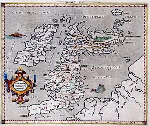
 The UK papers are covering what might seem at first glance to many to be a typical antiquarian-book auction, of an obscure and mistake-ridden mediaeval volume with an astronomical price tag due to its age, with contents of no intrinsic worth. (cf. “Little Britain - For Sale: World's First Printed Atlas", Daily Mail 7 Oct 06, “Atlas Favoured By Columbus Goes On Sale For £1 Million," Independent 7 Oct 06, and “Atlas Led Way To America, By Mistake“, The Times 7 Oct 06). For the volume is an old atlas showing countries bent out of shape and in the wrong place - cf. the map of Britain has Scotland bent over 90 degrees to the east. Being auctioned off at Sotheby’s in London, this Italian mediaeval hand-coloured atlas is nevertheless expected to fetch £1.5 million. (Individual maps not bound into atlases - or, more likely, cut out of them with an art knife - fetch over ten thousand dollars each.)
Known as the Cosmographia or Bologna Ptolemy, this was in fact the world’s first known printed atlas, dating from 1477, and was apparently the book used by Columbus. Most of the press stories say that when he made his 1492 New World landfall on a tiny Caribbean island, he believed he was in China or India (hence calling the natives ‘Indians’) because this atlas so underestimated the distance that it showed China in effect where the Caribbean is. Ptolemy’s atlas had just been printed when he embarked on his first merchant voyages. Not many people know that Columbus sailed not only west but north, and his son and biographer later wrote that, in 1477 (the same year the atlas was published), he visited ‘Thule.’ This is shown on the Ptolemy map of the British Isles, though it has never been geographically identified with certainty, Ultima Thule or “The Limit Of Thule” being the traditional Romano-Greek name for the farthest-north Atlantic island you could sail to.
Despite its inaccuracies, the volume does have intrinsic interest in that it contains maps dating right back to the Roman Era. Its 2nd-century AD compiler, the geographer Ptolemy (Claudius Ptolemaeus), known as the 'Father of Geography,’ lived in Alexandria where once stood the world’s greatest library of ancient manuscripts - before it was burnt by invaders. (This is apparently the only ‘pre-Columbian’ atlas to have survived, and itself nearly went up in flames more recently, when a house fire nearly consumed the late owner’s private library in Oxfordshire, the book being saved, along with 60,000 other maps, when the villagers rallied, forming a human chain to rescue the collection.)
Sotheby’s explains away the inaccuracies by saying Ptolemy had to base his maps on “travellers’ tales.” This is something of an over-simplification, for there were a number of early manuscripts known generically as periplous, the ancient Greek term for sailing guides, and by the Portuguese a portolan chart. Used by ship’s captains, these outlined directions, distances, harbours and other essential details, and were essential when sailors from the Mediterranean (where there are no tides) ventured out into the dangerous Atlantic, where tides and winds could sweep you helplessly away from land, or carry you onto rocky shores.
The standard map “projection” (whereby a round globe is drawn on a flat map) was created later by Mercator, who used Ptolemy’s maps. The theory that cartographic historians have come up with is that these periplous also included map coordinates where possible, and these were used by Ptolemy to sketch out his set of large-scale maps. The Ptolemy maps were the offshoot of such a guide book, a 7-part work known as Ptolemy's Geographia. This has lists of place names, Celtic tribal names, rivers etc. and probably derives from a parchment codex in the great library of Alexandria which was a compilation of individual periplous, perhaps incorporating the pioneering work of the 4th-century BC mercantile explorer Pytheas of Massilia. The archaeologist Sir Barry Cunliffe and others have argued that latitudes and crude longitudes of the Channel coast were taken as early as the 4th century BC by Pytheas, following the old tin-trade route north, which may also have been documented by the Phoenician founder of mathematical geography Marinus of Tyre.
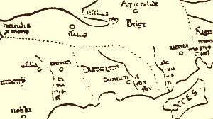
What is of particular interest here is the map of the British Isles. This the oldest known map of Britain based on charts, and the prominence given – literally - to southwest Britain suggests this region was important and well familiar to shipping. Southwest Britain is shown, as the Mail, the Telegraph, and Times all put it, “jutting out into the Bay of Biscay.” This prominence or distension is in itself technically an inaccuracy, but a telling one. For southwest Britain was where early "Phoenician" merchants sailed for, as the centre of the tin trade. Tin and lead mining operations and their associated trading entrepots evidently then stretched from Wight westward to Land’s End and up around to the Mendip Hills above Glastonbury – then a tidal sea-port.This is the rationale behind England’s “Holy Legend,” claiming that it was due to this that wealthy tin-trader Joseph of Arimatheia came to Britain with the first disciples, the Grail, and in some versions, his nephew Jesus as a boy. (On the morass of legend and Biblical lore behind the Holy Legend, see our earlier feature on Glastonbury here.) And although spelt out in Greek and Latin, the place-names given are not those of the Roman Occupation era, but older ones mentioned by early sources. The Isle of Wight for example, named Wectis or Ictis in Roman accounts and later versions of the map by Mercator et al, is originally Occes. (See sketch-map excerpt, below right.)
 (Both the Times and Mail articles include coloured illustrations, but these are not very detailed, though the Mail’s is at least enlargeable. For a larger-scale, later version, where you can make out place names, click here (U. Of Portsmouth's online map portal, which has a fullsize scan of Mercator’s 1578 version.)
Update: In the event, it went to an undisclosed private buyer for a record £2.14 million - the most expensive atlas ever sold at auction.


