
Every Xmas, the press run some inane Santa tie-in story, such as NORAD is tracking his sleigh. This year it touched on a new “Santa’s shortcut” air route crossing the Arctic Circle allowed by changing airline regulations. This may or may not really be news, but the transatlantic ‘shortcut’ route cutting across the Arctic is certainly not a new idea. Just as today’s Santa is the development of an ancient idea [see books by Phyllis Siefker, Paul Frodsham, Tony Van Renterghem, etc], the ‘Santa’s shortcut’ route continues an ancient practice as far as transatlantic crossings go. Now you may wonder, looking at a standard map, why would an airliner from, say, New York to London be flying over Greenland in the first place? Why not just fly a straight E-W route? (In fact, NYC is southwest of London, the Titanic took this south-westerly route – though it didn’t save it from an iceberg.)
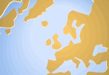
The answer lies in the deceptive standard map projection: plot the shortest course between, say, NYC and London on a globe with a piece of string, and you will find it skirts Iceland and traverses Greenland, crossing in and out of the Arctic Circle. Similarly, the route will show as a straight line on a ‘gnomonic’ map projection, a more accurate map projection, ironically said to be the world’s oldest, created in the 6C BC by the Greek scientist Thales.
But because this route appears as a curve on a flat Mercator-style map projection, it’s called a Great Circle Route. The airlines all follow Great Circle Routes and if you’ve never made the transatlantic crossing by air during daylight hours, get a window seat: take my word, I’ve made the trip several times, it’s well worth it for the view of the immensity of the North Atlantic (often littered with icebergs), Iceland and a whole slice of the Arctic Circle.
In fact, airlines have to fly a slight zigzag pattern over their GCR to maintain compass headings for set times, just as sailing vessels do, whether or not they are ‘tacking’ into head winds. And regulations requiring airliners to keep within x minutes of a place to land if need be, reflect the way sailors steer bearings that take them past a series of safe havens. In previous blog posts, we’ve discussed the importance of a type of ancient, carefully guarded, codex called a periplous, which was essentially a ship captain’s directional guide to a series of landfalls en route. And while it’s been assumed early seafarers didn’t have proper compasses, recently it’s been argued that they may have used the ‘sunstones’ referred to in the Norse sagas – crystal rocks which refract light differentially). However if you look at a map, the need to keep within a day’s sail (the Norse called this a doegr) of a harbour would take these vessels northward in any case, for the only landfalls for the North Atlantic crossing are up towards the Arctic Circle.

This fortunate coincidence, that the shortest route also has harbours more or less en route, allowed ancient Keltic and Nordic seafarers to cross the Atlantic. This so-called 'northern stepping-stone route’ arcs up NW from northern Britain or Scandinavia, past the Orkney Isles, passes within a day’s sail of the Shetlands, and then the Faeroes. There follows a dangerous open-water passage, NW over to Iceland, then the route heads NW again to make the shortest passage to the next landfall, SE Greenland, across the narrows of the Denmark Strait. There, midway once stood a lost land: a small group of habitable islets, now drowned by rising waters, called Gunnbjorn's Skerries. The sailing route then turned SW down Greenland’s east coast (helped by the current), continuing SW to landfalls on the North America continent, the closest of which is the tip of Newfoundland.
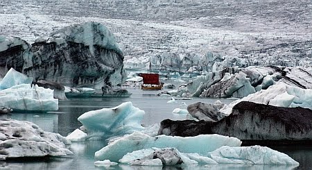
That this route was much used by early seafarers is not just a matter of map observation, for traces of Keltic and Nordic settlement have been found along these routes. The Nordics’ presence is well known, from the naming c980 AD of Greenland by Erik The Red (who should really have been called Erik The Ready Wit), through their use of Iceland as a base (attested in sagas) to the 1960s re-discovery of the ‘Viking’ settlement at L’Anse Aux Meadows on the northerly tip of Newfoundland, now a UNESCO World Heritage Site. That site, possibly settled by Erik’s son Leif Ericson, is usually identified as the land known in the Icelandic sagas as “Vinland the Good” (Vinland meaning Wine-Land) as it was then below the northerly limit for wild native grape-vines to grow (some identify Vinland as Nova Scotia). The search is still on for the sagas’ ‘Helluland’ (not an Erik The Red witticism, just Erik The Red’s son Leif Ericson’s ad hoc place-name, Old Norse for ‘Flat-Stone Land’ – possibly Baffin Island or northern Labrador) and Leif's ‘Markland’, meaning ‘Forest-Land’ which Leif also visited (somewhere farther south below the Arctic tundra/taiga treeline – possibly southern Labrador).
What is less well known, and is our concern here, is the presence of the earlier Keltic seafarers along this route. The orthodox view is that the Keltic presence which is found in Icelandic DNA etc is the result of Viking raiders taking slaves – mainly capturing Scots or Irish women to breed with. However the Nordic sagas themselves acknowledged the presence of earlier Keltic seafarers, referring to a land called Whitemansland (Hvítramannaland), or Irland-Mirka. This latter translates as Ireland-the-Great, usually rendered just as Greater Ireland. It is usually identified as Greenland, the idea being that there were Irish monastic settlements along the southerly coasts here. Its other name, Whitemansland, was taken from a native appellation for a land where (a native told the Norse) men in white robes processed carrying long poles with banners of white cloth and chanting loudly. They had "hair and skin as white as snow" and Whitemansland is sometimes translated Palefaces’ Land, paleface being a native term for the invading whites which survived in Hollywood-western Indian-speak, for what that’s worth. (Their white hair indicates older men, and another account says they wore a fringe, the shaved-pate effect which is the priestly tonsure in some orders.)
Early accounts exist in Latin as well as Icelandic Norse, and the terms used there are Hiberni (Hibernians, i.e. Irish), or Albani/albani, which can mean white men [when not capitalised] or men of Alban, a term for Britain [Greek Albion] and later in Gaelic sources for non-Romanised northern Britain. These are not just terms of origin, with Greater Ireland being translated as either Hibernia Major or Albania, suggesting more than just transient settlements. (The first Norse settlement in Iceland is dated to the reign of Pope Adrian, AD 772x795] while Greenland was first settled 986, by Eric The Red’s son Leif; the Norse abandoned their settlements in Greenland etc in the climate downturn of the 14th/15th Centuries.)

Here’s a quote from the first chapter of the Landnámabók, ‘The Book Of The Settlement Of Iceland’, which opens with how The Venerable Bede (historian and father of the English Church, fl. c.730) refers to old books that describe a land called Thule, ‘said to be six days' sailing north from Britain’, where ‘day came not in winter, nor night in summer’ (meaning it was above the Arctic Circle).
… before Iceland was peopled from Norway there were in it the men whom the Northmen called Papar; they were Christian men, and it is held that they must have come over sea from the west, for there were found left by them Irish books, bells, and croziers, and more things besides, from which it could be understood that they were Westmen [Irish]; these things were found east in Pap-isle and Papyle, and it is stated in English books that in those times voyages were made between these countries.
Do we have any Celtic codex sources on this presence? Sadly, there’s nothing that has survived quite like the Icelandic sagas, which are a distinct literary genre of historiography that developed as a written form after the Viking Age. De Mensura Orbis Terrae, a c825 geographical text by the Irish monk Dicuil (who may also be the anonymous Irish poet known as “Hibernicus exul”), describes the presence of a party of Irish monks who spent half a year on the farthest-north destination island of “Thule,” which is usually identified from details about the midnight sun as Iceland, but could be other sites to the east or west. With the Norse accounts that refer to these ‘papar,’ meaning fathers in the sense of priests, and place names like Pap-isle, are there not any more detailed matching Celtic church legends of far-flung anchorite colonies?

Legenda, meaning in Latin that which is to be read, were a then-popular ecclesiastical genre concerning saints’ lives - though unfortunately not reliable as historical accounts, the focus being on the fantastic and miraculous events the saint was involved with. Here, we do have a 8th C. composition, the Navigatio Sancti Brendani Abbatis, the Voyage Of Saint Brendan The Abbot, a strange legend concerning Irish seafaring monk St. Brendan The Navigator (one of the Twelve Apostles of Ireland), who sailed westward in a leather-and-woodframe currach c550 AD in search of the ‘Promised Land Of The Saints.’ A currach [spelling Anglicised as curragh; not to be confused with the small round Welsh coracle] is a Celtic seagoing-longboat design of unknown antiquity, but the associated boat-building skill is maintained in a few remote parts of the Gaeltacht [Gaelic-speaking area of western Ireland]. That it was possible to sail such a [twin-masted] currach across the north Atlantic, from Ireland to Newfoundland via Iceland, was demonstrated in 1976-7 by Tim Severin, in The Brendan Voyage, the title of a subsequent book and tv documentary. (Despite what you see in films, and the occasional reconstruction sailing voyage from 1893 onward, the Viking Norse didn’t use their dragon-prowed longships to cross the stormy seas, but a class of small merchant ship called knarr or knorr; I’ve read that the lifting action of Atlantic waves could break the back of a flat-keeled longship if one wave caught the bow and the other the stern.)

Even if St Brendan’s Navigatio was factually based, the actual route he and his fellow monks might have taken remains a matter of argument, for most of the legend’s strange encounters do not easily lend themselves to modern rationalising that would turn them into an account of an actual voyage or voyages past the Faeroes to Iceland and beyond (some argue all the way to Newfoundland). The Navigatio belongs to a then-popular type of marine wonder-tale genre known generically in Celtic as immram, and so incidents may have been copied from earlier now-lost instances. Tim Severin’s book, an international best seller, details his own route-rationale, which he explored with a 4,500-mile test voyage in his makeshift replica curragh; others have made their own research attempts on an armchair-travel basis using maps, ruler, compasses and textbooks. This has the advantage of tracing a set of different voyages which St Brendan may have made as the model for the tale as a composite adventure.
(The basic information is now all online, for anyone else who wants to have a look at it, starting with an English translation, here.) Of course, the Navigatio Sancti Brendani may be compiled from accounts by other papar, like Cormac, another Irish monk who is mentioned in Adomnán’s c700 Life Of St Columba as an intrepid sailor who went where no other had, over the uncrossable ocean to the north, but of whom we hear nothing more beyond Adomnan’s account.
More generally, regarding the problem of the lost discoveries and settlements by Keltic pioneers, one writer who has done ongoing field and literary research over several decades is veteran Canadian author Farley Mowat, who has written a series of books on this research area, culminating in his 1998 The Farfarers: Before The Norse (also issued in the UK as The Alban Quest: The Search For A Lost Tribe,1999). Mowat argues some sites classed as Norse really belonged to the Celtic seafaring settlers of North America he calls the Alban - largely the remnants of the Armorican tribes of Brittany enslaved by Caesar and later Picts from the Orkneys, driven ever westward by the advancing Norse. Mowat’s work is regarded by ‘serious’ historians as over-imaginative (he uses novelist’s techniques to add picturesque details), but academic research into such early transatlantic contact, which promotes the notion of multiculturalism, has of late acquired a certain respectability and impetus with a Worldwide Atlantic Conference in 2009, whose motto was, inevitably, 'Columbus was not first', and related pre-Columbian archaeo-finds such as this.
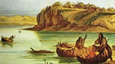
A less academically-respectable but separate longstanding line of enquiry by others has pursued the legend of a later (but still pre-Columbian) seafarer, the Welsh Prince Madoc discovering land to the west in 1170, and returning to Wales to escort a large fleet of colonists there. When the first American overland explorers crossed into the Ohio Valley, they discovered a tribe of native people called the Mandan, who they said bore odd similarities to the Welsh, in language as well boat-building style (round coracles on the Welsh pattern). This included the artist George Caitlin, who painted the coracle-like Mandan bull boat [pictured]. Sadly, the Mandans’ civilisation was almost wiped out by smallpox in the 1830s, right after Catlin visited.
But the controversy has continued ever since, the Welsh-Mandan claim being disputed as crypto-racism, or flagged up as English propaganda going back to the Tudor kings (Tudor was a Welsh name, Tewdr) to extend English geopolitical claims farther south, from the 16th century onwards. Hakluyt’s famous ‘Voyages’ even had Iceland seized for England by the fleet of mighty King Arthur – who even if real would scarcely have been English himself, but was adopted by the Welsh Tewdr/Tudor dynasty as a propaganda tool; Hakluyt was recycling and updating a part of Geoffrey of Monmouth’s 1135 (pre-Madoc) mythmaking Arthurian opus the Historia Regum Brittanorum, to promote English gains in the New World by Raleigh et al.) Although it got nowhere academically (though there is a U. Of Wales scientific research vessel called Prince Madoc) or politically (beyond local speculative commemorations), the Madoc story has lived on in literature.

For those interested in the Arthurian legend, this later northern-route tie-in to the legend has added a distinct subgenre of this subject area. This is based on the notion that the original legendary “isle of apples” Avalon, where Arthur was taken when mortally wounded and possibly also where the Holy Grail with its healing power was kept, was based on somewhere across the North Atlantic, some real island or peninsula on North America’s east coast, which a Celtic religious order used as the ultimate secret retreat. Like the Promised Land of the Saints, the Celtic Otherworld, after all, was somewhere to the West – perhaps it was a real place, a secret burial isle, perhaps a place of convalescence a wounded hero, if fortunate, might one day return from, or at least retire to, living out his days in peace?
Various writers have entertained the New World Avalon thesis, dating back at least to Arthurian-Glastonbury author Geoffrey Ashe in Land To The West, 1963, focusing on St Brendan’s voyage. Later entries, post the bestselling Holy Blood, Holy Grail, are more conspiracy-oriented, focusing on the Templars, Freemasons and related ‘hidden-history’ cover-ups: Michael Bradley in Holy Grail Across The Atlantic, 1988, Andrew Sinclair in The Sword And The Grail: The Story Of The Grail, The Templars And The True Discovery of America, 1992, and Graham Phillips, in Merlin And The Discovery Of Avalon In the New World, 2005 [feature and cliff-hanging Ch. 1 online here and here). This is not entirely a new inspirational idea: there are Avalon place names on the map of eastern Canada in Newfoundland, notably the Avalon Peninsula, named after England’s official Province of Avalon colony, designed and given a Royal Charter in 1623 as a Glastonbury-style religious refuge (sadly, the long winters proved too much for the intended farming commune).

The ultimate goal in these early nor’westerly voyages of exploration was distant Thule, whose popular appellation in Latin (thanks to the poet Virgil) of Ultima Thule indicated it was believed to be the most northerly limit of land in the world. Today, we know this limit would be the north coast of Greenland, which is never approachable by sea except by modern icebreaker vessels. (The US built an airbase nearby which they called Thule.) But from descriptions of visits by various sailors (including Columbus) giving lengths of daylight, ancient Thule is usually taken to be Iceland, on the edge of the Arctic Circle – although again it could be lands east or west at a comparable latitude. (As Dava Sobel‘s 1996 bestseller Longitude details, establishing one’s E-W longitude remained a problem for mariners well into the 18C.)

The earliest visitor to write an account of visiting Thule for Greco-Roman readers was Pytheas c325 BC, who said he sailed there, near the edge of the congealed sea. Inevitably he was denounced as a liar, mainly by the Roman geographer Strabo (who never visited), and his book Peri Tou Okeanou (‘On The Ocean’) was lost to posterity (we have only passages quoted by others like Strabo). Pytheas was from Massilia, the modern Marseilles, then a Greek colony in the western Med offering trade access to mainland Gaul and points beyond, and this raises the prospect that Pytheas, who was a private citizen rather than an official, travelled with the help of local sailors, perhaps first from Gaul and then from Britain, who knew the north Atlantic trade routes.
In modern times, the surviving references to Pytheas’s lost book have allowed a re-appraisal by scholars such as Rhys Carpenter (Beyond The Pillars Of Hercules, 1966) and Prof Barry Cunliffe (The Extraordinary Voyage Of Pytheas The Greek, 2001). I have both these books and they definitely concur that Pytheas’s observations (which include latitude measurements using a gnomon or sundial-type calibrated measuring stick) are reasonable even if not that accurate. I suspect ‘Thule’ [pronounced Tooley] however was an obsolete pre-Keltic and then a poetic classical name meaning simply the far-away [cf Greek tele, ‘at a distance’], and was attached by different map-makers to different islands and peninsulas, from Norway to Shetland, the Faeroes, Iceland and Greenland. Thus, no set of coordinates given or geographic description matches up with the next. As the subarctic island-stepping-stone trade route opened up, the symbolic name Ultima Thule for the farthest land retreated like a mirage, reassigned to the next potential landfall on the next generation of maps being made back home.
It’s quite possible the notion of yet-another unknown island was kept alive for its confusion value - disinformation to maintain secrecy over trade routes. Just last year a rare giant map parchment scroll 6.75 m long, the Tabula Peutingeriana, was put on display as the only example of its type to survive. This was drawn in the 13C but based on 4C and older Roman sources giving official itinerary i.e. highway-stopover info, for the entire imperial road network, showing how it reached out to the ends of the known world. You can see from the detail I’ve reproduced below, taken from the map’s NW top-left corner there is a string of 3 small unnamed islands leading westward from “Jbernia Ins.” [Hibernia = Ireland] and ending with “Thyle Ins[ula]”. The stretched-planisphere scroll format means that neither directions or distances shown are to be taken seriously. The Romans were such hopeless mariners that it is more likely the Ultima-Thule stepping-stone route shown here derives from 2nd-hand info, perhaps from the work of Pytheas himself, for no Roman expedition seems to have followed up his circumnavigations (hence the arguments lasting for centuries between Roman writers over the accuracy of his observations).

Thus, we’ve come full circle, back to where transatlantic map-making explorations began. Nevertheless, I would argue there is a reasonable supposition that Celtic mariners knew the sea route from mainland Europe as far northwest as Shetland (at 600 N.) and probably Iceland (and the pack ice of the Frozen Sea beyond) as far back as c325 BC, and may well have crossed all the way to the New World in their currachs.
What is needed is archeo evidence regarding the traces of early settlement along the route indicated above, by Keltic monastic refugees, traders, fishermen and whalers etc. Author Farley Mowat visited many such sites, compiling fieldwork notes largely from local reports, and his 1998 The Farfarers: Before The Norse aka The Alban Quest: The Search For A Lost Tribe, has original outline maps sketching in a large number of these possible sites. Copyright restrictions discourage me from reproducing them here, but the book is still available online, detailing Mowat’s arguments. For example, he felt that the roofless ruins found around these coasts are a reflection of an old Scots-Irish practice where you use your longboat as the roof of your shelter on such distant shores where no suitable trees etc are to be found locally; thus he argues L’Anse aux Meadows may be a Keltic site rather than a Norse one.


